The Coming of the Europeans – Early Exploration of New England

Select your language to auto-translate:

EnglishEspañolFrançaisDeutschItalianoDansk中文(简体)中文(漢字)日本語한국어PortuguêsTürkçeالعربية

Extracted from 1632 Map of North America - source Map reproduction courtesy of the Norman B. Leventhal Map Center at the Boston Public Library

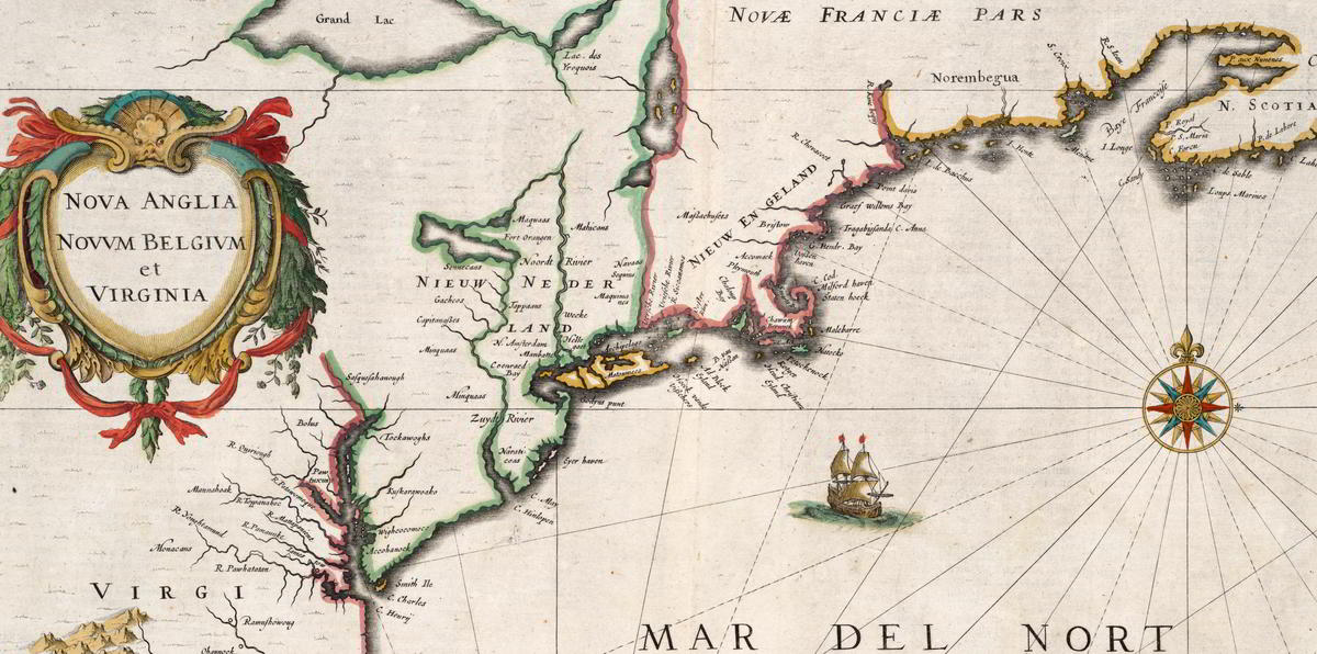
Extracted from 1632 Map of North America – source Map reproduction courtesy of the Norman B. Leventhal Map Center at the Boston Public Library

This is Part 2 of a series about the founding of New England. For Part 1, the Native Americans, click here.

In the 1400’s, even before Christopher Columbus’s fabled voyage to “discover” America, Basque fisherman commonly fished for cod in the area around what was to be called Newfoundland. In 1497, under the aegis of English King Henry VII, the Genovese explorer Giovanni Caboto (John Cabot), while searching for a spice route to Asia, noted a land with a vast, rocky coastline teeming with cod. Cabot called this “New Found Land,” and claimed it for England. By the early 1500’s, it was common for English fishing ships to visit and harvest the cod from this area.

In parallel efforts, in 1501 the Portuguese explorer Gaspar Corte-Real reached what is now the state of Maine and abducted over 50 Native Americans; the Native Americans were sold into slavery. In 1523 the Italian Giovanni da Verrazano sailed into Narragansett Bay, near present-day Providence, RI, and spent over two weeks trading as a guest of the Natives. After leaving Narragansett, he sailed north and encountered the Abnacki on the coast of Maine. In 1534, Frenchman Jacques Cartier “discovered” and explored the mouth of the St. Lawrence river, claiming the area for France. (Cartier was later involved in colonization efforts, but these were abandoned in 1543.)

By the end of the 1500’s, European exploration in North America had become common, but was focused on fishing the plentiful cod. Permanent settlements did not exist and the fisherman-explorers went home as winter approached. Universally, the Europeans noted that North America was thickly settled with natives, generally described as handsome and healthy. And, the area seemed ripe for exploitation. European attention began to shift to the more systematic capitalization of North America. This resulted in the emergence of “trading companies” set up to establish permanent settlements to harvest the riches.

In 1602, English explorer Bartholomew Gosnold established a small post on Cuttyhunk Island (in the Elizabethan Islands near Cape Cod and New Bedford), but had to abandon the outpost as the group had inadequate supplies to last the winter.  During this visit, Gosnold is credited with naming “Cape Cod” and discovering Martha’s Vineyard. (In 1607 Gosnold was involved in the founding of Jamestown, the first permanent English settlement in North America.)

In 1605, French explorer Samuel de Champlain, known as the founder of “New France” in North America, helped to found Port-Royal, the first successful French Settlement in North America. In 1605-1606, he visited Cape Cod with plans to establish a French base. This plan was abandoned after skirmishes with the Natives. In 1608, Champlain founded what is now known as Quebec City, on the Saint Lawrence River in Canada.

Englishman Sir Ferdinando Gorges, the “Father of English Colonization in North America”, was planning to develop settlements in Maine – then considered “the Northern Parte of Virginia.”  In 1605, he was part of the sponsoring group for an expedition sent to explore the area of New England under Captain George Waymouth. During his voyage, Waymouth captured  five Native Americans, who he brought back to England. According to some accounts, one of the captured Indians was Squanto – the same Squanto who was to play a key role in helping the Pilgrims survive their first winter in North America.  After 1605, many English voyages carried one or more Native Americans as guides and interpreters.

In 1606, again initiated by Gorges, the Sagadahoc settlement (also known as Popham) at base of Kennebec near modern Portland, Maine became the first English attempt at colonizing New England.  It was abandoned after only one year.

In 1609, sponsored by the Dutch East India Company to seek a northwest spice passage, English explorer Henry Hudson passed by the Atlantic Coast and up the river that was to bear his name. Hudson claimed a good part of the territory between Virginia and New England for the Dutch. Their first settlement, for fur trading, was established near present day Albany, New York, in 1615. Dutch colonization efforts did not start until 1624, with the land that was to become their capitol, New Amsterdam, not purchased from the Native Americans until 1626.

In 1614, the English explorer Captain John Smith was ordered by the future King Charles I to sail to America to assess commercial opportunities. Smith reached land in present-day Maine and made his way south to Cape Cod, making contact with natives and mapping out the coastline. Smith called the region “New England.”

During the mapping, Smith observed the land that was to become Boston. He noted a tri-capped hilly peninsula with an excellent harbor. The harbor was fed by three rivers and connected to the mainland by a narrow neck across a shallow back bay. Called “Shawmut,” it was important to the natives for an excellent freshwater spring.

This all was setting the scene for the first permanent settlement in New England in 1620, the Pilgrim’s voyage to what became Plymouth. But, that is another story.

Guide to Boston’s Unique Geography and Changing Landscape

Boston Primary Landfill Projects Since 1775

Annotated 1895 Boston Map Illustrating Landfill Projects

Select your language to auto-translate:

EnglishEspañolFrançaisDeutschItalianoDansk中文(简体)中文(漢字)日本語한국어PortuguêsTürkçeالعربية

One of the most fascinating and overlooked aspects of Boston is how much the land-form has changed over the years.  What you experience today is over 50% landfill.  Places you walk, such as the area around Faneuil Hall, were actually part of the harbor when Boston was founded in 1630.

When the first visitors arrived, they found a salamander-shaped, rocky, hilly, peninsula that was formed by erosion at the end of the last ice age.  Called Shawmut by the Native Americans, it was small, two miles long and only a mile wide.  It’s only connection to the mainland was the low-lying, narrow, wind-swept Boston Neck, which often flooded at high tide and was impassable during stormy weather – meaning the peninsula became an island.  During the siege of Boston, the British troops were effectively blockaded into this tiny island, without adequate food or firewood.

The peninsula was dominated by three hills, hence its early name of Trimountaine, which was later shortened to Tremont – a name that lives on in today’s Tremont Street. There was Copp’s Hill (in the North End), Beacon Hill (which had three summits and was almost twice as high) and Fort Hill (which was located in today’s financial district).

[embedplusvideo height=”365″ width=”450″ standard=”http://www.youtube.com/v/y3QlGzJW27c?fs=1″ vars=”ytid=y3QlGzJW27c&width=450&height=365&start=&stop=&rs=w&hd=0&autoplay=0&react=1&chapters=&notes=” id=”ep8086″ /]


Today’s Boston was created by a series of land reclamation projects, which started in a small way soon after the Puritans arrived in 1630 (you can see the 1630 water line marked in the pavement near the Samuel Adams Statue behind Faneuil Hall).

The major landfill projects took place between 1807 and about 1900, although some reclamation projects extended until almost 2000. Much of the land for the early projects came from the leveling of Fort Hill and from Beacon Hill. The largest project, the filling in of the Back Bay took, spanned several generations between 1856 and about 1894. For that project, gravel was transported in on a specially built train line from Needham, a suburb about nine miles away.  One of the first of the second generation steam shovels was used to fill the gravel cars for the trains, which ran around the clock for almost fifty years.

For a fantastic website, which was used to create the animations in the video above, visit the Boston Atlas. It is simply the best place to play with Boston’s changing topography, and was a great source for this post. Also visit the Norman B. Leventhal Map Center at the Boston Public Library – a wonderful source of historic Boston maps, many of which were used in the creation of this post and the accompanying video.  For those interested in learning more, there is another interesting post from Professor Jeffery Howe at Boston University; for that post, click here.

Freedom Trail Boston Video Virtual Tour in 5 Minutes

A 5 minute comprehensive video walk through of The Freedom Trail, it features all the 16 official Freedom Trail Stops, more than 50 unofficial Stops, historic restaurants, and other interesting places in and around The Freedom Trail – all included in theFreedom Trail Boston – Ultimate Tour Guide – Tips, Secrets & Tricks eBook. It moves fast as it contains almost 150 photos and video segments, so keep your pause key handy if you want to view anything in detail. A must see for anyone visiting The Freedom Trail and Colonial Boston.

The video was created as a companion to the  eBook “Freedom Trail Boston – Ultimate Tour and History Guide,” now available on Amazon.com. The Guide covers all of the sites in the video and more. In addition to any touring information the reader might need, the Guide provides detailed historical context from the time of Boston’s founding through events like the Boston Massacre, the Boston Tea Party, Paul Revere’s Ride, the Battles of Lexington and Concord, and the Charles Bulfinch era. In short, it contains everything someone might want to know to visit and enjoy The Freedom Trail and Revolutionary Boston.

For a companion map to the video, see my custom Google Map posting. The map includes everything in the video.

Enjoy the video!

Freedom Trail Historic Boston Restaurant Guide & Map


View Freedom Trail Boston – Ultimate Tour Map & Guide in a larger map

For those visiting the Freedom Trail and wishing the immersive experience, there are a number of historic restaurants directly on or close to the Freedom Trail.

The Google Map above displays these restaurants along with the sixteen official Freedom Trail stops and many other interesting sites on or near the Freedom Trail.  It is also available as a free Android app (iPhone/iPad versions to be available soon).

All these restaurants, sites and much is discussed in the eBook “Freedom Trail Boston – Ultimate Tour & History Guide – Tip, Secrets, & Tricks“.

BTW, none of these restaurants should be considered “fine dining,” with the possible exception of the Chart House. But, all are fun and serve good food.  And, they will absolutely enhance your Freedom Trail experience.  Most have excellent lunch specials.  Enjoy!

1654 – Green Dragon Tavern

Green Dragon Tavern Boston on Historic Marshall Street

Green Dragon Tavern on Historic Marshall Street

The original Green Dragon Tavern was a around the corner at 84 Union Street. It was founded in 1654 and an active pub by 1714. The Green Dragon was a regular haunt for the Sons of Liberty and the site of the Boston Tea Party planning meetings.  It was torn down in 1828.

The current Green Dragon incarnation is fun and has decent bar food.  It is located on Marshall Street, one of the oldest most authentically historic in Boston.  Right next door is the Ebenezer Hancock House – which built in 1767 by John Hancock’s uncle, inherited by John and then given to his brother, Ebenezer.  Ebenezer became the deputy paymaster to the Continental Army.

Special at the Green Dragon Tavern Boston

Lobster Specials at the Green Dragon Tavern Boston

Good lunch specials, including lobster.  Everyone needs at least one lobster when visiting Boston!

Green Dragon Tavern website

617-237-2114

1742 (perhaps 1713) – Union Oyster House

Union Oyster House on Boston Freedom Trail

Union Oyster House

The Union Oyster House started serving in 1826. It is the oldest continuously operating restaurant in the US.  The building, which dates from 1742 (although other references place it as early as 1713), started its life as a dress shop.  At that time, the harbor actually came up to the dress shop’s back door.  Since then, all the land you see has been filled in.

Old Bar at the Union Oyster House

Daniel Webster’s Seat at the Union Oyster House

The legendary Oyster Bar at the front of the restaurant is beautiful and historic.  Regular customer Daniel Webster sat daily at this bar and drank a tall tumbler of brandy and water with each half-dozen oysters – usually eating at least six plates.

Union Oyster House website

617-227-2750

1760 – Chart House

Chart House Restaurant - Hancock's Counting House - 1760

Chart House Restaurant – John Hancock’s Counting House

The Chart House was originally the Gardiner House, built on Long Wharf around 1760. Later, it was John Hancock’s counting house.  It is the oldest building still in use on Long Wharf.

For the pleasant weather, it has outside seating with a great view of the harbor and downtown Boston. It is the most elegant restaurant in this collection.

Chart House website

617-227-1576

1780 – Warren Tavern

Warren Tavern Charlestown - by Bunker Hill

Warren Tavern – by Bunker Hill

Built in 1780, the Warren Tavern was reportedly the first building raised after the British burned Charlestown during the Battle of Bunker Hill in 1775. It is named for Doctor and General Joseph Warren, the famous Patriot who was killed at Bunker Hill. It was visited by George Washington, Paul Revere, and Benjamin Franklin.

Warren Tavern in Charlestown - by Bunker Hill

Warren Tavern – Historic and Good Pub Food by Bunker Hill

Good pub food and great slice of history.

Warren Tavern website

617-241-8142

Freedom Trail Maps with Google Map Tour

Any visitor to the Freedom Trail and Colonial Boston will need good maps.  Here are several – all free.

The Google map below was created for the eBook Freedom Trail Boston – Ultimate Tour and History Guide. In itself, the map is almost a full tour guide and includes the essentials for all the official, as well as many interesting unofficial Freedom Trail sites. All of the Official Stops come with web-based auto-translate links that allow the user to specify the language for the post. A great feature for non-English comfortable users.

The map also provides information such as operating hours, websites, phone numbers, admission costs and handicap access notes.  There are even listings for the best historic restaurants. Here is a video post that includes all the sites listed in the map.

The map is also available as a FREE full-blown Android app, downloadable from Google Play as well as from the Amazon App Store. The app exposes all the best features of Google Maps and is, by far, the most usable way to use the map. It  performs better than using a browser, is much less awkward, and lets you keep the map easily identifiable and ready to launch.

Use it (at your own risk as travel information is subject to change), enjoy it, and please comment.  Pass the link on to your friends.

View Freedom Trail Map & Historic Boston Guide in a larger map


Next is a series of official Freedom Trail maps from the US National Park Service (NPS).  These are savable, printable,  well done and all paid for by US tax dollars.

The main Freedom Trail Map, which is the same that you will see on the NPS Freedom Trail Guide paper guide, is available here.  It is also available from The Freedom Trail Foundation here.  Additionally, there are other relevant visitor maps available from the National Park Service – for the whole series click here.  In addition to the official Freedom Trail map mentioned above, there is a less detailed Freedom Trail map with an outline of Boston’s harbor line at 1775 – fascinating for historical context.  Click here for the 1775 overlay map.  The series also includes maps for the Charlestown Navy Yard,  Boston Harbor in WW II, a map that shows walking distances between Boston sites (Boston is a very walkable city), and a guide for tour bus parking.


Map of Referenced Machu Picchu Locations


View Machu Picchu Sites in a larger map

Map of locations described in Steve’s Guide to Cuzco and Machu Picchu

Map of Referenced Cuzco Locations


View Important Cuzco Travel Sites in a larger map

Map of locations described in Steve’s Guide to Cuzco and Machu Picchu

Boston and New England Map

A listing of all the places referenced in Steve’s Travel Guide.  Please zoom to the desired level and enjoy – Steve.


View Steve’s Boston and New England Map in a larger map