Archives for 2014

Ultimate Freedom Trail Tour Guide & Apps – Tips, Secrets & More

Select your language to auto-translate:

EnglishEspañolFrançaisDeutschItalianoDansk中文(简体)中文(漢字)日本語한국어PortuguêsTürkçeالعربية

“… just the right mix of content to make for a terrific tour…” David J. Asher  “Saved me with visitors from the West Coast…”  Steve S.

Download the free Apps – use with the Guide or by themselves when visiting the Freedom Trail!

For the iPhone                 For Android 

The Freedom Trail Boston – Ultimate Tour & History Guide provides everything you need to bring your visit to The Freedom Trail to life. Use it to plan your visit, as a interactive tour guide, or even as a souvenir! Includes FREE STREAMING AUDIO NARRATION – a personal tour guide in your pocket (requires web access)!

The most comprehensive guide available, by far!

  • Overview and detailed background information for all 16 Official and >50 Unofficial Freedom Trail Stops
  • Side trips to Harvard Square/Cambridge, Lexington, Concord, Adams NHP, & Boston Harbor Islands
  • Available in print or ebook formats.
  • Print version retains ebook features with QR Code access to auto-translate and web materials
  • > 70 photographs, maps and illustrations
  • Auto-translate all major book chapters (with web-access) into Spanish, French, German, Italian, Japanese, Chinese, Korean and more
  • Access to additional free information including an interactive Google Map Tour, an Android app and iPhone/Pad app
  • Budget tips including the best free guided-tours, where to find a bargain lobster, historic restaurants, and even a harbor cruise for $3 (children are free)
  • Detailed itineraries for an hour, 1/2, full and two day visits. Learn exactly what to visit with your limited time
  • Child-friendly and family-oriented tips
  • Descriptions of all the events that bring the Freedom Trail to life including the Boston Massacre, the Boston Tea Party, Paul Revere’s Ride, the Battles of Lexington and Concord, and the Battle of Bunker Hill – more than is provided by any other tour guide


波士顿自由之路介绍 – 怎样安排最佳游览路线!

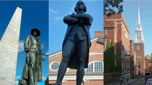
Prescott SAdams & OldNorthChurch on Boston Freedom Trail

自由之路全长2.7英里

红砖标出的街道连接着

16处重要的历史古迹或“站点”。

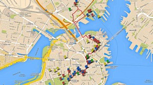
Freedom Trail Google Map Enhanced

它的正式起点是在

波士顿公园,终点在查尔斯顿的

邦克山纪念碑。


在一天之内全部游览完比较困难特别是如果您想参观每个站点。


这里还有许多非正式的

站点 -当您漫步时

您所看到的和您想要了解的。


请记住,这些站点不是按历史顺序排列的,

尽管从地理位置上能看到有些站点很靠近。


大多数的站点是以革命时代主题,但其中一些最受欢宪法号战舰迎的站 还要古


根据您的兴趣和计划,请确定您有足够的时间去参观您想看的。


关于距离,直接从正式的

自由之路起点波士顿

公园到法纳尔大厅大约只有0.6英里(1公里),

不超过15分钟。


从法纳尔大厅步行到的保罗里维尔故居需要10到15分钟。到查尔斯顿站点还需步行15分钟从考普山墓地和旧北教堂。北边的最后的站点到宪法号战舰和邦克山纪念碑还需要和步行10分钟。


从查尔斯顿回到波士顿,最佳建议之一 – 因为

步行一天之后可能感到很乏味

可以坐水上巴士。它从查尔斯顿的宪法号博物馆后面的

海军船厂开始到水族馆和波士顿万豪酒店旁的

长码头为止。很有趣,价格也不贵(成人只需三美金12岁以下儿童免费),这是从港口体验波士顿风情的不错的。


方法 –怎么做的呢?


最推荐的是选择

免费的国家公园导游,从法纳尔大厅

开始,特别是参观北边时,

那是波士顿我最喜欢的地方。


我喜欢的站点宪法号战舰,小朋友们也都喜欢的;旧州府

大楼,有奇妙的博物馆,非常不错的解说。

有还优旧北教堂。


说实话,我并不想省略其它站点,但

如果时间非常有限,那些只能是候选。


祝您游览愉快!


请购买从亚马逊或在波士顿购买“波士顿自由之路 – 最终旅游和历史指南”。它包括自动翻译,交互式地图,智能手机应用程序,推荐路线,小提示,除了参观自由之路外,还有哈佛,列克星敦,以及更多!


从iTunes或Google Play下载免费的应用程序。https://www.stevestravelguide.com/?p=1122

Freedom Trail Boston Visit Planning Video

Posted this as an intro for folks planning to visit the Freedom Trail.  Hope that it is helpful to visualize the trail length and breadth as well as some of the Stops.

Enjoy and have a great visit.


The Coming of the Europeans – Early Exploration of New England

Select your language to auto-translate:

EnglishEspañolFrançaisDeutschItalianoDansk中文(简体)中文(漢字)日本語한국어PortuguêsTürkçeالعربية

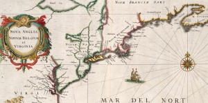
Extracted from 1632 Map of North America - source Map reproduction courtesy of the Norman B. Leventhal Map Center at the Boston Public Library

Extracted from 1632 Map of North America – source Map reproduction courtesy of the Norman B. Leventhal Map Center at the Boston Public Library

This is Part 2 of a series about the founding of New England. For Part 1, the Native Americans, click here.

In the 1400’s, even before Christopher Columbus’s fabled voyage to “discover” America, Basque fisherman commonly fished for cod in the area around what was to be called Newfoundland. In 1497, under the aegis of English King Henry VII, the Genovese explorer Giovanni Caboto (John Cabot), while searching for a spice route to Asia, noted a land with a vast, rocky coastline teeming with cod. Cabot called this “New Found Land,” and claimed it for England. By the early 1500’s, it was common for English fishing ships to visit and harvest the cod from this area.

In parallel efforts, in 1501 the Portuguese explorer Gaspar Corte-Real reached what is now the state of Maine and abducted over 50 Native Americans; the Native Americans were sold into slavery. In 1523 the Italian Giovanni da Verrazano sailed into Narragansett Bay, near present-day Providence, RI, and spent over two weeks trading as a guest of the Natives. After leaving Narragansett, he sailed north and encountered the Abnacki on the coast of Maine. In 1534, Frenchman Jacques Cartier “discovered” and explored the mouth of the St. Lawrence river, claiming the area for France. (Cartier was later involved in colonization efforts, but these were abandoned in 1543.)

By the end of the 1500’s, European exploration in North America had become common, but was focused on fishing the plentiful cod. Permanent settlements did not exist and the fisherman-explorers went home as winter approached. Universally, the Europeans noted that North America was thickly settled with natives, generally described as handsome and healthy. And, the area seemed ripe for exploitation. European attention began to shift to the more systematic capitalization of North America. This resulted in the emergence of “trading companies” set up to establish permanent settlements to harvest the riches.

In 1602, English explorer Bartholomew Gosnold established a small post on Cuttyhunk Island (in the Elizabethan Islands near Cape Cod and New Bedford), but had to abandon the outpost as the group had inadequate supplies to last the winter.  During this visit, Gosnold is credited with naming “Cape Cod” and discovering Martha’s Vineyard. (In 1607 Gosnold was involved in the founding of Jamestown, the first permanent English settlement in North America.)

In 1605, French explorer Samuel de Champlain, known as the founder of “New France” in North America, helped to found Port-Royal, the first successful French Settlement in North America. In 1605-1606, he visited Cape Cod with plans to establish a French base. This plan was abandoned after skirmishes with the Natives. In 1608, Champlain founded what is now known as Quebec City, on the Saint Lawrence River in Canada.

Englishman Sir Ferdinando Gorges, the “Father of English Colonization in North America”, was planning to develop settlements in Maine – then considered “the Northern Parte of Virginia.”  In 1605, he was part of the sponsoring group for an expedition sent to explore the area of New England under Captain George Waymouth. During his voyage, Waymouth captured  five Native Americans, who he brought back to England. According to some accounts, one of the captured Indians was Squanto – the same Squanto who was to play a key role in helping the Pilgrims survive their first winter in North America.  After 1605, many English voyages carried one or more Native Americans as guides and interpreters.

In 1606, again initiated by Gorges, the Sagadahoc settlement (also known as Popham) at base of Kennebec near modern Portland, Maine became the first English attempt at colonizing New England.  It was abandoned after only one year.

In 1609, sponsored by the Dutch East India Company to seek a northwest spice passage, English explorer Henry Hudson passed by the Atlantic Coast and up the river that was to bear his name. Hudson claimed a good part of the territory between Virginia and New England for the Dutch. Their first settlement, for fur trading, was established near present day Albany, New York, in 1615. Dutch colonization efforts did not start until 1624, with the land that was to become their capitol, New Amsterdam, not purchased from the Native Americans until 1626.

In 1614, the English explorer Captain John Smith was ordered by the future King Charles I to sail to America to assess commercial opportunities. Smith reached land in present-day Maine and made his way south to Cape Cod, making contact with natives and mapping out the coastline. Smith called the region “New England.”

During the mapping, Smith observed the land that was to become Boston. He noted a tri-capped hilly peninsula with an excellent harbor. The harbor was fed by three rivers and connected to the mainland by a narrow neck across a shallow back bay. Called “Shawmut,” it was important to the natives for an excellent freshwater spring.

This all was setting the scene for the first permanent settlement in New England in 1620, the Pilgrim’s voyage to what became Plymouth. But, that is another story.

New England Before Europeans – the Native Americans

Select your language to auto-translate:

EnglishEspañolFrançaisDeutschItalianoDansk中文(简体)中文(漢字)日本語한국어PortuguêsTürkçeالعربية

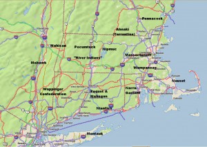
Rough Locations of Primary New England Native American Tribes

Rough Locations of Primary New England Native American Tribes

Map © 2008 DeLorme (www.delorme.com) TOPO USA® – Annotations by the Author

By the time white Europeans arrived, New England had been inhabited by Native Americans for over a thousand years. Migrating here after the retreat of the last ice age, by 1500 they had a population likely in excess of 100,000. Originally hunters and gatherers, they had become more agricultural – with extensive fields of corn (maize), beans, and squash.  By this time the tribes were fundamentally stationary, but shifted dwellings several times year based on weather – winter, autumn hunting, and summer.

The New England tribes had a common heritage and belonged to the Algonquian family. Their language was fairly common, and although each tribe had nuances, there was the ability to be understood from Cape Cod to Canada.

Politically, each tribe and sub-tribe had a single primary ruler, called “sachem” or “sagamore”.  These sachem were usually men, but sometimes there were squaw, or female, sachem.  Within the tribal hierarchy, there were sub-sachems for functions such as the military (for war), powwows (medicine), and other functions.

At the time of the white man’s arrival, there were a number of principle tribes, many peaceful, but some warlike and in competition with their neighbors. The names of these tribes have been inherited by many New England towns, rivers and lakes. Those tribes included:

  • The Abnaki, also known as the Tarrantine to other tribes, inhabited western Maine, especially the Kennebec Androscoggin & Saco River valleys, as well as portions of neighboring New Hampshire. As this is the colder and more mountainous portion of New England, the Abnaki tended more to hunting than farming. More warlike than their southern neighbors, many tribes, and particularly the Massachusetts, lived in dread of Tarrantine raids. They had a reputation for cruelty and were accused of cannibalism by the English.
  • The Penacook inhabited southern and central MA, northeastern MA and southeastern ME, with the principle subdivision around Concord, NH. The Penacook had many subordinate tribes including the Nashua, Piscataqua, and the Winnepesaukee.
  • The Massachusett (in Algonquian, “people of the great hills”), from whom the state of Massachusetts got its name, inhabited the eastern area of state, around Boston. Originally one of the more powerful tribes, it was devastated by the plague and wars with the Abnaki. Their population declined from about 3,000 to 500 between 1615 and 1630.
  • The Wampanoag inhabited the areas of southeastern Massachusetts near where the Pilgrims landed in current Plymouth. They were also devastated by the plague. Metacom (King Philip of “King Philip’s War”) was Wampanoag.
  • The Narragansetts were a powerful tribe that lived in present-day Rhode Island.
  • The Niantics were a largely coastal tribe lived on Narragansett Bay, and extended as far west as the Pequot tribe in Connecticut.
  • The Pequots, of eastern Connecticut were originally part of the Mahican (known as Mohegan, a corruption of the Mahigan name) a tribe of the of upper Hudson River valley in New York.  They were warlike and aggressive and the primary protagonist in the Pequot War in 1637-1638.
  • The Nipmucs who inhabited central MA, were a comparatively weak tribe who frequently paid tribute to their neighbors.
  • The Pocumtucks were a loose association of tribes that lived west of the Nipmucks in the areas around Deerfield, MA.
  • South of the Pocumtucks along the Connecticut River Valley lived the “River Indians”, another loose association of tribes.
  • Bordering the River Indians to the west was the Wappinger Confederacy, which extended from the west bank of the Hudson River as far south as Manhattan and north to Poughkeepsie. Tribes of the Wappinger included the Mattabesic, Quinnipiac, Paugusset, and Tunxis.
  • North of the Wappinger Confederacy were the Mahicans, (Mohecan), the parent tribe to the Pequots. They inhabited the western Connecticut and the upper Hudson Valley in New York.
  • The Nausets were a smaller tribe that lived on Cape Cod.
  • The Montauks inhabited eastern Long Island.
  • The Mohawks, who spanned most of eastern New York State, were the easternmost tribe of the Iroquois confederacy, e.g., they were not Algonquin. Extremely warlike, they were formidable and feared by the Algonquin tribes.

Between 1616 and 1619 a plague, or the “Great Dying,” wiped out almost ¾ of the New England Native American population, with the devastation worse in the coastal areas where mortality was as high as 95%. A major effect was that when white settlers began arriving, starting in 1620, they encountered very little of the indigenous population. The Native American’s ability to resist the Europeans was very weak.

For Part 2, the Early Exploration of New England, click here.

Sources and for additional reading:

Bragdon, Kathleen Joan, Native People of Southern New England, 1500-1650.  University of Oklahoma Press, 1996.

Vaughan, Alden T., New England Frontier Puritans and Indians 1620-1675.  Little Brown and Company Boston, 1965.

http://iweb.tntech.edu/kosburn/History-201/Puritans%20&%20Indians.htm

http://www.memorialhall.mass.edu/classroom/curriculum_6th/lesson2/bkgdessay.html

http://www.smithsonianmag.com/history-archaeology/squanto.htm


Boston Harbor Islands – Fantastic Day Trip For All Ages

Select your language to auto-translate:

EnglishEspañolFrançaisDeutschItalianoDansk中文(简体)中文(漢字)日本語한국어PortuguêsTürkçeالعربية


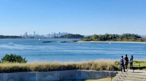
View from Georges Island Artillery Observation Tower

View of Boston across the Harbor from Georges Island Artillery Observation Tower

A fantastic trip and relaxing change from Revolutionary Boston is a visit to the Harbor Islands National Recreation Area. At the Islands you can visit a Civil War era fort, swim, picnic, hike, bird watch, camp, enjoy a concert, or just delight on the wonderful, narrated cruise through the Harbor. For the younger visitors there is even a playground with an amazing view of the Boston skyline. The Islands are a cooperative effort between the National Park Service and various Commonwealth, City and private groups.

The park itself features 12 islands and peninsulas, and even the oldest active lighthouse station in the United States (used since 1716, only accessible via a special “Lighthouse Tour”); practically, you can visit a maximum of two Islands per day – visiting a single Island requires at least ½ day, but don’t rush. There is a snack shack with a seafood menu on Georges Island, but the food quality can be variable – so you may want to pack a lunch. There is an expertly-staffed pavilion on the Rose Kennedy Greenway between Quincy Market and Long Wharf to help plan your visit, purchase ferry tickets, etc.

Although ferries run from several suburban locations, most visitors will take the ferry the north side of Long Wharf (by Christopher Columbus Park); the ferries take you to either George’s or Spectacle Island. From George’s Island, during the summer, there are connections to other islands. Fares are: Adults, $15; children 4-11, $9; over 65, $11, inter-island, $3. Regular service runs May through Columbus Day in the fall, but there are various winter visit opportunities. Definitely visit the website for current and detailed visiting and transportation information.

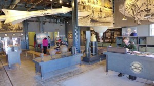
There is a very well done Visitor Center on Georges Island with interpretive exhibits highlighting the Islands’ history, their role in the defense of Boston, the impacts of changing military technology, even the respective diets of enlisted men and officers – fascinating even for the non-military-oriented visitor. Unless you know you want your stop to be Spectacle Island, stop here first, watch the eight minute video and plan the rest of your visit. Rangers are there to help.

There are excellent Ranger-led tours of the Civil War era Fort Warren, which was built between 1833 and 1861 (self-guided tours are also available). During the Civil War, the fort served as a prison for over 1,000 Confederate personnel, the most famous the Confederate Vice President Alexander Stephens. Fort Warren remained active through the Spanish-American War and World War I. During World War II, it was part of the harbor’s defense from German U-boats. Over the years it was modified to accommodate changing cannon technology. It was permanently decommissioned in the 1950’s when guided missiles obsoleted cannon for coastal defense.

A visit is highly recommended and suitable for all ages. Handicap access, however, is limited; please check the website for detailed information.

Useful links for a Boston Harbor Islands visit:

  • The official Boston Harbor Islands website.

  • National Park Service website.

  • National Park Service map of the Islands, download here.

  • Boston Harbor Islands YouTube channel, here.

  • Ferry website.

  • The Boston Harbor Island Alliance website.

Georges Island Visitor Center

Georges Island Visitor Center