Ultimate Freedom Trail Tour Guide & Apps – Tips, Secrets & More

Select your language to auto-translate:

EnglishEspañolFrançaisDeutschItalianoDansk中文(简体)中文(漢字)日本語한국어PortuguêsTürkçeالعربية

“… just the right mix of content to make for a terrific tour…” David J. Asher  “Saved me with visitors from the West Coast…”  Steve S.

Download the free Apps – use with the Guide or by themselves when visiting the Freedom Trail!

For the iPhone                 For Android 

The Freedom Trail Boston – Ultimate Tour & History Guide provides everything you need to bring your visit to The Freedom Trail to life. Use it to plan your visit, as a interactive tour guide, or even as a souvenir! Includes FREE STREAMING AUDIO NARRATION – a personal tour guide in your pocket (requires web access)!

The most comprehensive guide available, by far!

  • Overview and detailed background information for all 16 Official and >50 Unofficial Freedom Trail Stops
  • Side trips to Harvard Square/Cambridge, Lexington, Concord, Adams NHP, & Boston Harbor Islands
  • Available in print or ebook formats.
  • Print version retains ebook features with QR Code access to auto-translate and web materials
  • > 70 photographs, maps and illustrations
  • Auto-translate all major book chapters (with web-access) into Spanish, French, German, Italian, Japanese, Chinese, Korean and more
  • Access to additional free information including an interactive Google Map Tour, an Android app and iPhone/Pad app
  • Budget tips including the best free guided-tours, where to find a bargain lobster, historic restaurants, and even a harbor cruise for $3 (children are free)
  • Detailed itineraries for an hour, 1/2, full and two day visits. Learn exactly what to visit with your limited time
  • Child-friendly and family-oriented tips
  • Descriptions of all the events that bring the Freedom Trail to life including the Boston Massacre, the Boston Tea Party, Paul Revere’s Ride, the Battles of Lexington and Concord, and the Battle of Bunker Hill – more than is provided by any other tour guide


波士顿自由之路介绍 – 怎样安排最佳游览路线!

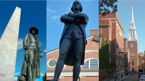
Prescott SAdams & OldNorthChurch on Boston Freedom Trail

自由之路全长2.7英里

红砖标出的街道连接着

16处重要的历史古迹或“站点”。

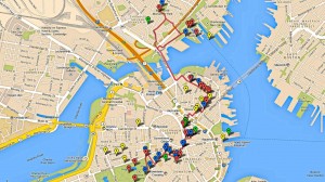
Freedom Trail Google Map Enhanced

它的正式起点是在

波士顿公园,终点在查尔斯顿的

邦克山纪念碑。


在一天之内全部游览完比较困难特别是如果您想参观每个站点。


这里还有许多非正式的

站点 -当您漫步时

您所看到的和您想要了解的。


请记住,这些站点不是按历史顺序排列的,

尽管从地理位置上能看到有些站点很靠近。


大多数的站点是以革命时代主题,但其中一些最受欢宪法号战舰迎的站 还要古


根据您的兴趣和计划,请确定您有足够的时间去参观您想看的。


关于距离,直接从正式的

自由之路起点波士顿

公园到法纳尔大厅大约只有0.6英里(1公里),

不超过15分钟。


从法纳尔大厅步行到的保罗里维尔故居需要10到15分钟。到查尔斯顿站点还需步行15分钟从考普山墓地和旧北教堂。北边的最后的站点到宪法号战舰和邦克山纪念碑还需要和步行10分钟。


从查尔斯顿回到波士顿,最佳建议之一 – 因为

步行一天之后可能感到很乏味

可以坐水上巴士。它从查尔斯顿的宪法号博物馆后面的

海军船厂开始到水族馆和波士顿万豪酒店旁的

长码头为止。很有趣,价格也不贵(成人只需三美金12岁以下儿童免费),这是从港口体验波士顿风情的不错的。


方法 –怎么做的呢?


最推荐的是选择

免费的国家公园导游,从法纳尔大厅

开始,特别是参观北边时,

那是波士顿我最喜欢的地方。


我喜欢的站点宪法号战舰,小朋友们也都喜欢的;旧州府

大楼,有奇妙的博物馆,非常不错的解说。

有还优旧北教堂。


说实话,我并不想省略其它站点,但

如果时间非常有限,那些只能是候选。


祝您游览愉快!


请购买从亚马逊或在波士顿购买“波士顿自由之路 – 最终旅游和历史指南”。它包括自动翻译,交互式地图,智能手机应用程序,推荐路线,小提示,除了参观自由之路外,还有哈佛,列克星敦,以及更多!


从iTunes或Google Play下载免费的应用程序。https://www.stevestravelguide.com/?p=1122

Freedom Trail Boston Visit Planning Video

Posted this as an intro for folks planning to visit the Freedom Trail.  Hope that it is helpful to visualize the trail length and breadth as well as some of the Stops.

Enjoy and have a great visit.


High-Resolution Photos from Freedom Trail Boston – Ultimate Tour & History Guide

Select your language to auto-translate:

EnglishEspañolFrançaisDeutschItalianoDansk中文(简体)中文(漢字)日本語한국어PortuguêsTürkçeالعربية

One of the great frustrations in publishing an eBook is that the publisher is megabyte constrained – e.g., there is an incentive to keep eBooks small.

High resolution photos use up a lot of megs.  So, to keep things small, the photos in the eBook are either 800 x 600 or 640 x 480 and have been compressed. They are illustrative and fine for an eReader, tablet or phone, but this resolution does not do them justice as photographs.

The gallery below contains the photos used in the “Freedom Trail Boston – Ultimate Tour & History Guide – Tips, Secrets & Tricks” eBook in 2048 x 1536 format compressed to +/- .5 meg each.  I’ve also include a few pictures that simply did not fit or that are representative of what you will see on and around the Freedom Trail. If anyone is interested in one in native format, 4000 x 3000 +/- 5 meg each, email me and we’ll figure something out.

Warmest regards,

Steve

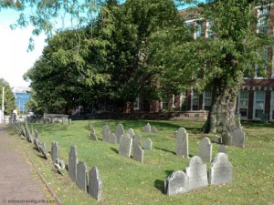
Copp’s Hill Burying Ground – Freedom Trail Stop 14 Overview

Copp's Hill Burying Ground - Freedom Trail Stop 14 - 1659

Copp’s Hill Burying Ground – Freedom Trail Stop 14 – 1659

Select your language to auto-translate:

EnglishEspañolFrançaisDeutschItalianoDansk中文(简体)中文(漢字)日本語한국어PortuguêsTürkçeالعربية

Site of British Battery During Battle of Bunker Hill

Founded in 1659, Copp’s Hill’s permanent residents include the Puritan ministers Increase and Cotton Mather, Robert Newman (the patriot who hung the lanterns that signaled “two if by sea” in Old North Church), and Prince Hall, the father of Black Freemasonry.

Free – public park  Closed as it gets dark  Official website:

http://www.cityofboston.gov/parks/hbgi/CoppsHill.asp

Handicap access limited as it is up a steep hill from Old North Church and there are several steep granite steps to climb in order to enter the burying ground.  No restrooms

Public transportation: Green or Orange line to North Station.

Plan 10-15 minutes to walk through and view the grave sites.

Background Information

Copp’s Hill Burying Ground, the second oldest in Boston, was founded in 1659. It takes its name from William Copp, the North End shoemaker who was the original owner of the land. The hill is the highest in the North End and originally was the sight of windmills, the source of its original name of Windmill Hill. The burying ground was extended several times as the need increased. The earliest grave markers date to 1661.

On the Snow Hill Street side are the many unmarked graves of the African Americans who lived in the “New Guinea” community at the foot of the hill. In addition to the graves, there are 272 tombs, most of which bear inscriptions that are still legible.

Among the Bostonians buried here are the family of the original owner, William Copp, as well as Robert Newman (the Sexton of the Old North Church who hung the “two if by sea” signal lanterns). Also here is Prince Hall along with many unmarked graves of African Americans who lived on Copp’s Hill. Prince Hall was one of the most influential free black leaders in the late 1700s. Hall is known for his work for education rights, as an early abolitionist, and as the father of Black Freemasonry.

The most historically significant memorial is the Mather Tomb, the final resting place for Increase (1639-1723) and his son Cotton Mather (1663-1728). Both Mathers were powerful and politically active ministers of the Old North Meeting House (Boston’s Second Church), which was in North Square by the Paul Revere House. They were directly involved in the hysteria surrounding the Salem witch trials which damaged their reputations.

When the British occupied the city during the Siege of Boston, in 1775-1776, Copp’s Hill Burying Ground was used for target practice. You can still see impact marks from British musket balls, particularly on the headstone of Captain Daniel Malcom. There’s even one in the eye of the skull!

Copp’s Hill was also the site of British cannons that were mounted to protect the harbor. During the Battle of Bunker Hill, these cannons were used to bombard Charlestown prior to the British assaults. You can see the Bunker Hill Monument and the USS Constitution from the back of the Burying Ground.

Narrowest House

Diagonally across the street from the Burying Ground entrance is the narrowest house in Boston. It is 10.4 feet (3.16 m) at its widest, it tapers to 9.2 feet (2.82 m) at the back. It was allegedly built as a “spite house” a little after 1874.

Old North Church – Freedom Trail Stop 13 Overview

Old North Church - Freedom Trail Stop 13 - 1723

Old North Church from Copp’s Hill – 1723

Select your language to auto-translate:

EnglishEspañolFrançaisDeutschItalianoDansk中文(简体)中文(漢字)日本語한국어PortuguêsTürkçeالعربية

The Steeple that Started the Revolution

In April, 1775, it was the sight of the hanging lanterns that notified Patriots in Charlestown that the British were leaving “two if by sea” prior to Paul Revere’s Midnight Ride and the Battles of Lexington and Concord.

Admission. Check for availability and rates: https://www.oldnorth.com/admission-pricing/  Separate admission for Crypt tour (worthwhile).

Sunday services 9 and 11 AM

Official website:

http://oldnorth.com/

617-523-6676

Handicap access – there is a 1/2″ step at entrance to church; gift shop limited.

No restrooms in the Church

Public transportation: Green or Orange line to Haymarket Station.

Plan about 15 minutes to walk through.

Excellent gift store next to the Church.

.

Bckground Information

Old North Church, officially known as Christ Church, was begun in 1723 and took twenty-two years to complete. It is the oldest church remaining in Boston. On April 18, 1775 its place in history was cemented when Sexton Robert Newman climbed the steeple and hung the two lanterns that signaled to Patriots watching from Charlestown that the British were marching on Lexington and Concord “by sea”.

Old North was the second Anglican Church in Boston, after King’s Chapel. As an Anglican Church, the majority of its congregation was loyal to the British King and the membership included the Royal Governor. The King gave Old North its silver and a bible.

The fact that this is an Anglican Church makes its place in American history even more extraordinary as it made the use of the Church by Revere and Newman extremely risky. After hanging the lanterns, Newman had to escape out a window. (The original window through which he left the church was bricked up in 1815. It was rediscovered during restoration work in 1989.) Paul Revere was never a church member as he was a Congregationalist. He did, however, work here as a bell ringer.

Old North was modeled after the work of Sir Christopher Wren in London, perhaps using St. Andrews-by-the-Wardrobe in Blackfriars, London as the model. St. Andrews-by-the-Wardrobe was destroyed by German bombs during World War II, but has since been rebuilt.

The original steeple was destroyed in a storm in 1804 and Charles Bulfinch designed the replacement, which stood until Hurricane Carol in 1954. The current steeple uses design elements from both the original and the Bulfinch version. The church steeple now stands 175 feet (53 m) tall, some sixteen feet lower than the original. At its tip, however, is the original weather vane.

The church bells, the oldest in America, came from England and date from 1744. They were restored in 1894 and again in 1975. They ring regularly, and are beautiful – check the website for the bell ringing schedule.

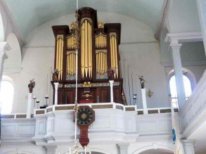
Old North Church Showing Clock & Organ

Old North Church Showing Clock (1726) & Organ (1759)

Many of the church details are original. The high box pews were purchased by congregation members in a manner similar to the way season tickets to sporting events are purchased today – buy first in the back and trade up when a better seat opens up. The pews high walls are designed to retain the warmth of hot coals or bricks placed on the floor. The chandeliers are from England.

The organ, built in 1759, still has some original components and is used. The clock was built by some of the parishioners in 1726. To the left of the pulpit there is a lifelike bust of George Washington that dates from 1815. During his visit in 1824, the Marquis de Lafayette, a key aid of Washington, commented on the extremely lifelike nature of the bust.

Old North’s basement holds some 1,100 bodies buried in 37 in crypts. It was used between 1732 and 1853, and each tomb is sealed with a wooden or slate door, with many doors still covered by the plaster ordered by the city in the 1850s (see in the Behind-the-Scenes tour).

The founding rector of the church, Timothy Cutler, was buried right under the altar. Also buried under the church is British Marine Major John Pitcairn, who was mortally wounded at the Battle of Bunker Hill and entombed with many others killed in that battle.

Freedom Trail Tour Guide – Maps, Sites, Tips & Secrets

Select your language to auto-translate:

EnglishEspañolFrançaisDeutschItalianoDansk中文(简体)中文(漢字)日本語한국어PortuguêsTürkçeالعربية

“… just the right mix of content to make for a terrific tour…” David J. Asher  “Saved me with visitors from the West Coast…”  Steve S.

Download the free companion Apps – use with the Guide or when visiting the Freedom Trail!

For the iPhone                 For Android 

The Freedom Trail Boston – Ultimate Tour & History Guide provides everything you need to bring your visit to The Freedom Trail to life. Use it to plan your visit, as a interactive tour guide, or even as a souvenir! Includes FREE STREAMING AUDIO NARRATION – a personal tour guide in your pocket (requires web access)!

The most comprehensive guide available, by far!

  • Overview and detailed background information for all 16 Official and >50 Unofficial Freedom Trail Stops
  • Side trips to Harvard Square/Cambridge, Lexington, Concord, Adams NHP, & Boston Harbor Islands
  • Available in print or ebook formats.
  • Print version retains ebook features with QR Code access to auto-translate and web materials
  • > 70 photographs, maps and illustrations
  • Auto-translate all major book chapters (with web-access) into Spanish, French, German, Italian, Japanese, Chinese, Korean and more
  • Access to additional free information including an interactive Google Map Tour, an Android app and iPhone/Pad app
  • Budget tips including the best free guided-tours, where to find a bargain lobster, historic restaurants, and even a harbor cruise for $3 (children are free)
  • Detailed itineraries for an hour, 1/2, full and two day visits. Learn exactly what to visit with your limited time
  • Child-friendly and family-oriented tips
  • Descriptions of all the events that bring the Freedom Trail to life including the Boston Massacre, the Boston Tea Party, Paul Revere’s Ride, the Battles of Lexington and Concord, and the Battle of Bunker Hill – more than is provided by any other tour guide


What is The Freedom Trail?

Freedom Trail Logo Boston

Welcome to The Freedom Trail

The Freedom Trail is the largest attraction in New England, with over three million visitors a year. It is fun, walkable, accessible, family-friendly, engaging, and a bargain. You can see it in 1/2 a day, or spend several days and still want more.

Select your language to auto-translate:

EnglishEspañolFrançaisDeutschItalianoDansk中文(简体)中文(漢字)日本語한국어PortuguêsTürkçeالعربية

And, Boston has everything you might want in a destination – world class museums, fantastic restaurants, shopping, sports, music, theater and history. It’s a unique and charming place that can feed almost any passion. There are great options for almost any budget, even a bargain lobster lunch.

So, what is it? The Freedom Trail is a 2.5 mile red brick path  (mostly brick – some lines are painted) that connects 16 significant historic sites, referred to as “Stops” throughout this blog.  The Trail starts at Boston Common and officially ends at the Bunker Hill Monument in Charlestown.

Most of the Stops are free and many are handicapped accessible, but some may be difficult to navigate for non-walkers. For the few that charge admission, there are discounted tickets available.

The original idea for The Freedom Trail was conceived by William Schofield, a long-time journalist for the now defunct Boston newspaper, the Herald Traveler. In 1951, Schofield had the idea for a walking path that connected Boston’s great collection of local landmarks. With the support of local historians, politicians and businessmen, the Freedom Trail was born.

In addition to the official Stops, there are many “unofficial Stops” you pass as you traverse the Trail, or are very near by. Most unofficial Stops are directly associated with Revolutionary Boston and The Freedom Trail, but some are simply interesting places.  Many folks include them in their Freedom Trail visit.

So, how should you plan for your visit, and for how long? The posts on Planning to Tour, Part 1 and Part 2, will give you an overview of all the official Stops, a sense of how long it takes to visit each, and alternative itineraries for 1/2, full and two day tours. Use this free custom Google Map to help visualize your visit – it is practically a full blown self-touring guide in itself. For a complete view of The Freedom Trail, get a copy of the “Freedom Trail Boston – Ultimate Tour & History Guide – Tips, Secrets & Tricks“.
The influence Boston had on the thinking and actions that led to the American Revolution was extraordinary. Without Boston and its unique history, the American colonies break with Great Britain may have still happened, but not when and how it did. The Freedom Trail presents the essence of Revolutionary Boston and brings its amazing impact to life.

Enjoy, Boston is a unique city and The Freedom Trail is a national treasure.

The Freedom Trail Tour Planning – Part 2

In Part 1 of this series, I provided an assessment for the time needed to visit each of the 16 official Freedom Trail Stops. In this post, I’ll suggest itineraries for 1/2, full and two day tours. If you can, plan for a full day (or more), especially if you want to spend time visiting any particular Stop. However, if it’s all you have, a 1/2 day is still fantastic, and it takes two days for an in-depth visit.

Select your language to auto-translate:

EnglishEspañolFrançaisDeutschItalianoDansk中文(简体)中文(漢字)日本語한국어PortuguêsTürkçeالعربية

Below find alternatives for 1/2 day, full day and two day visits. Use the custom Google Map referenced here to help you visualize what you are seeing and help as you walk your tour.

Most of the downtown Stops are close together. Walking directly from Boston Common (Stop 1) to Faneuil Hall (Stop 11) is only about .6 miles (1 km) and takes less than 15 minutes. Walking from downtown Faneuil Hall to the Paul Revere House in the North End (Stop 12) takes 10-15 minutes, but you pass through the Blackstone block, one of my favorites and a great place for a lobster lunch.

The Charlestown Stops (USS Constitution and Bunker hill) are another 15+ minute walk from the last Stop in the North End (Copp’s Hill Burying Ground), and there is a 10+ minute walk between the USS Constitution and Bunker Hill. If you can, save energy for the climb up the Bunker Hill monument, the view from the top is spectacular on a nice day.

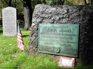
Sam Adams & Boston Massacre Victims in Granary Burying Ground

Sam Adams & Boston Massacre Victims in the Granary Burying Ground

To review, the official stops are:

Stop 1 – Boston Common.

Stop 2 – The Massachusetts State House.

Stop 3 – Park Street Church.

Stop 4 – Granary Burying Ground.

Stop 5 – King’s Chapel.

Stop 5a – King’s Chapel Burying Ground.

Stop 6 – Boston Latin, Old City Hall, Franklin Statue.

Stop 7 – Old Corner Book Store.

Stop 8 – Old South Meeting House.

Stop 9 – Old State House.

Stop 10- Boston Massacre Site.

Stop 11 – Faneuil Hall and National Park Service visitor center.

Stop 12 – Paul Revere House.

Stop 13 – Old North Church.

Stop 14 – Copp’s Hill Burying Ground.

Stop 15 – USS Constitution and the Charlestown Navy Yard.

Stop 16 – Bunker Hill Monument.

1/2 Day Tour Recommendations:

Option 1: (Downtown) Walk by Stops 1 – 3, visit Stops 3 – 5, walk by 6-8, visit 9, walk by 10, and visit 11. Lunch and break at Faneuil Hall Market or the Blackstone Block area.

Option 2: (Downtown and North End): Walk by Stops 1 – 3, visit Stops 3 – 5, walk by 6 – 10, visit 11, walk by 12, visit 13 and 14. Lunch and break in Faneuil Hall Market, the Blackstone Block or the North End.

Option 3: (Charlestown – USS Constitution and Bunker Hill): Visit Stop 15 USS Constitution (bypass the Constitution Museum and USS Cassin Young), visit Bunker Hill Monument and Museum. Lunch at the Warren Tavern or at the Navy Yard.

Option 4: (Charlestown, USS Constitution): Spend a full 1/2 day visiting the USS Constitution, the Museum, USS Cassin Young and walk around the Navy Yard. Lunch at the Navy Yard or across the Bridge in the North End.

Option 5: (A little Downtown, free ranger-guided tour, North End, USS Constitution – requires a lot of walking and tour-time coordination): Start at Stop 11, Faneuil Hall, and listen to the NPS Great Hall talk, take the NPS  tour that goes to the North End, visit Stops 13 – 15, take the Water Shuttle back to Long Wharf.

Full Day Tour Recommendations:

Boston and the North End: Walk by Stops 1-3, visit Stops 3-5, walk by 6-7, visit 8 and 9, walk by 10, visit 11, lunch or break in Faneuil Hall Market, the Blackstone Block or the North End, visit 12-14.

Charlestown: spend a full 1/2 day visiting the USS Constitution, the Constitution Museum, USS Cassin Young and walk around the Navy Yard, lunch around the Navy Yard or at the Warren Tavern, visit the Bunker Hill Monument and Museum.

If you want to visit the entire Freedom Trail in a single day, it is recommended that you combine Options 2 and 3. It will be busy and there is a lot of walking, but you will have a great time.

Two Day Recommendations:

For a two day visit, combine both of the full day recommendations. It is worth the time if you can spare it.

What would I do?

If I could fit in a flexible half day, especially with kids, without question Option 5. This requires planning to fit in the National Park Service ranger tours, but is absolutely worth it. Start at Faneuil Hall  and enjoy the Great Hall ranger talk (every 1/2 hour) and get a sticker for the ranger-tour that goes to the North End (currently at 12, 2 & 3 PM – stickers available 1/2 hour prior. Confirm times at the NPS visitor center.) After the tour, visit Old North Church (Stop 13), walk through Stop 14, then walk quickly to Stop 15 and take the USS Constitution tour. Take the Water Shuttle back to Long Wharf (every 1/2 during non-commuting hours). Grab lunch where you can.

If I only had half a day, wanted to self-guide, and could not coordinate times for Option 5, I’d recommend Option 2 with a lobster lunch in the Blackstone Block. See as much as you can, and the North End has fantastic character and European feel. Don’t miss a Faneuil Hall tour or visiting the Old State House. If you are not from New England, the lobster is not to be missed.

If I had a full day, combine Options 2 and 3. The downtown stops are great and I love the Navy Yard and USS Constitution (it is easy to spend too much time here). Bunker Hill and the Bunker Hill museum are excellent. Have a lobster lunch in the Blackstone Block or grab some character and a Paul Revere Burger at the Warren Tavern in Charlestown (I’d choose the lobster, but it may be too early in your day).

Have a great visit.

The Freedom Trail Tour Planning – Part 1

Select your language to auto-translate:

EnglishEspañolFrançaisDeutschItalianoDansk中文(简体)中文(漢字)日本語한국어PortuguêsTürkçeالعربية

The entire Freedom Trail is only 2.5 miles long, but seeing it all in one day is difficult,  especially if you want to spend time visiting any particular Stop. To help you plan your visit, I’ve provided a quick assessment for each of the official 16 Stops, its significance to the Revolutionary period, and the recommended time needed for a visit. Where relevant, I’ve also mentioned unofficial Stops you will pass along the way.

In Part 2 of this series, there are specific recommendations for 1/2, full and two day tours. Use this custom Google Map to help visualize and plan your tour.

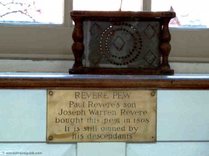
Paul Revere Pew in Old North Church

Revere Pew in Old North Church

Stop Review:

Note: Most of the downtown (Stops 1 through 11) are close together. Walking directly  from Boston Common to Faneuil Hall is only about .6 miles (1 km) and takes less than 15 minutes.

Stop 1 – Boston Common. A great old park, but unless you want to walk around the park and enjoy the outdoors, there is not much of prime historical importance to see. There is a good playground for younger children at Frog Pond.

Stop 2 – The Massachusetts State House. There are excellent guided tours and it is a fascinating and elegant old building, Plan 1.5-2 hours to pass through security and take the tour. While it is worthwhile, there is not much relating to the Revolutionary period as the State House was built after the Revolution. Take the time to view St. Gauden’s Robert Gould Shaw & MA 54th Memorial across the street at the edge of Boston Common.

Stop 3 – Park Street Church. Closed for viewing except during the summer. Unless you take a tour, it will not take much time. There is little of primary Revolutionary significance.

Stop 4 – Granary Burying Ground. This is the final resting spot for Sam Adams, John Hancock, Paul Revere, Mother Goose, the Boston Massacre victims, and others. Plan about 15 minutes to walk through.

Stop 5 – King’s Chapel. Great old church usually open for viewing. Plan 15 minutes to walk through.

Stop 5a – King’s Chapel Burying Ground. The oldest in Boston, plan about 10 minutes to walk through and view the old stones. Not much of Revolutionary significance as the Burying Ground was full well before 1700.

Stop 6 – Boston Latin, Old City Hall, Franklin Statue. Everything is outside (there is no interior viewing of Old City Hall). Plan 5-10 minutes to view the outside plaques.  If you want to see the Province House steps, plan for another 5 minutes to walk up Province Street.
Stop 7 – Old Corner Book Store. You will walk by and see the house, which now houses a Chipotle Mexican Grill. Nothing to tour.

Stop 8 – Old South Meeting House. Plan 1/2+ hour to view inside and the exhibits. The Meeting House is interesting given the number of important Revolutionary-era meetings that took place here. There are interpretive exhibits that place the building and its events in history and a good three dimensional map of Revolutionary-era Boston that highlights key locations – fascinating given the city’s changing topology. Check their web site for other programs. Benjamin Franklin’s birthplace and the Irish Memorial are directly across the street and are quick to see.

Stop 9 – Old State House. The Old State House features excellent docent-given tours and talks that cover the building and Revolutionary events. The museum has some good displays and exhibits. Plan about an hour to visit and take a tour. Highly worthwhile.

Stop 10 – Boston Massacre Site. This is a plaque embedded in the street directly below the balcony of the Old State House. This is a walk-by with a photo opportunity.

Stop 11 – Faneuil Hall. This is a great old and important building. Go inside and enjoy a Ranger-led talk (given every 30 minutes). Plan for 30-45 minutes to visit the Hall. The Faneuil Hall Marketplace (Quincy Market) is located next door, and is a good place to stop, get something to eat or shop. Plan accordingly. The new National Park Service visitor center is located in the first floor of Faneuil Hall.

Note: From Faneuil Hall, it is a 15 minute walk to the next official Stop, the Paul Revere House, in the North End. On the way, you pass some interesting unofficial Stops in the Blackstone Block area – the Holocaust Memorial, Union Oyster House, Marshall Street, and the Ebenezer Hancock House. The Blackstone Block is also a good, less commercial place to take a break or to eat. Some of the local restaurants feature good lobster specials at lunch.

Stop 12 – Paul Revere House. Built in 1680, it is the oldest structure remaining in Boston. It is a good example of a period dwelling and you will gain insights into Paul Revere’s life. The costumed docents provide interesting descriptions of the house and the Revere family. Visiting is worthwhile, but the house is small, consisting of only four rooms. Plan for about 1/2 hour.

Note: It is about a 10 minute walk through the North End to the next stop. The North End is also an excellent place to stop for lunch. It has a very European feel and many wonderful restaurants.

Stop 13 – Old North Church. A beautiful and important church, the oldest remaining in Boston. A walk through takes about 15 minutes. Purchase the $1 pamphlet that illustrate the highlights.

Stop 14 – Copp’s Hill Burying Ground. An 5 minute walk up hill from the Old North Church. Plan about 10-15 minutes to walk through the Burying Ground. There are a few interesting graves, a headstone used by the British for target practice, and a nice view of the harbor.

Note: From here there is another 15+ minute walk across the bridge to Charlestown and the next Stop, the USS Constitution.

Stop 15 – USS Constitution and the Charlestown Navy Yard. Visiting the Constitution and the Museum can easily be a half day visit. For the Constitution alone, plan at least an hour to pass through security, view the small museum and take the guided tour of the ship. The very good USS Constitution Museum (different from the small museum attached to the Constitution), is worth another hour. A walk around the USS Cassin Young will take another 1/2 hour. Walking around the Navy Yard area is also a pleasure, and there are a few restaurants in the neighborhood. This is a highly worthwhile 1/2 day, especially for children, who will enjoy exploring the ships.

Note: There is another 15 minute walk between the Charlestown Navy Yard and the Bunker Hill Monument and Museum. For a historic lunch, try the Warren Tavern, which is only a short detour between the two sites.

Stop 16 – Bunker Hill Monument. To tour the monument area, plan about 15-20 minutes, unless you plan to make the 294-step ascent to the top. That is a fun activity and provides a spectacular view of Boston and the surrounding area. If climbing the Monument, plan 1/2 hour. To visit the Bunker Hill Museum, which is excellent and best seen before the monument, plan another 1/2 to full hour. The museum features exhibits on the battle and Charlestown history, and has ranger-guided programs – great for children. If you have time, visit the Museum before the Monument. Highly recommended.

Boston’s North End – More Than “Little Italy,” A Brief History

Select your language to auto-translate:

EnglishEspañolFrançaisDeutschItalianoDansk中文(简体)中文(漢字)日本語한국어PortuguêsTürkçeالعربية

Most people know the North End as Boston’s Little Italy. But, Italians did not start moving into the North End in any significant number until the 1880’s – some 260 years after the North End’s earliest residents. The Italians were only the last of a series of ethnic groups to inhabit this area of Boston.

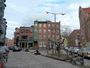
Boston's North End

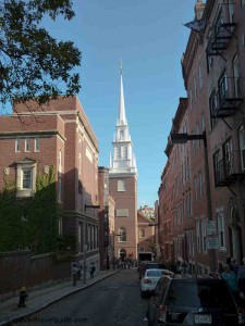
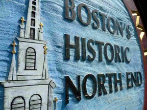
Entering Boston’s Historic North End

Originally, the North End was a suburb for the Puritan families who migrated to Boston during the 1630’s. At that time, the North End was isolated, virtually an island surrounded by water on three sides, connected to the rest of Boston by a small neck of land.

Over time, was the land connecting the North End to Boston was filled-in, but the North End remained geographically isolated until the completion of the Big Dig in 2007. In recent history, and prior to the Big Dig’s completion, easy entry to the North End was blocked by the elevated Central Artery (Route 93).

By the mid 1640’s the North End had evolved into its own distinct community. By 1649, it was large enough to have its own church, the North Meeting House (later called Boston’s Second Church).

In 1659, the North End established its own Burying Ground, Copp’s Hill. Copp’s Hill took its name from William Copp, a shoemaker who had owned once owned the land. Copp’s Hill was also home to a free black population, many of whom are interred in the Burying Ground.

North Square boston

North Square – Looking at Site of Second Meeting House

The area around the North Meeting House developed into North Square, which quickly became the center of North End life. At that time, North Square was only one block from the harbor.

Increase Mather, the minister of the North Meeting House, had his home in North Square. It, along with the Meeting House and a number of surrounding buildings, was destroyed in the fire of 1673. The Meeting House was rebuilt and subsequently torn down by the British and used for firewood during the Siege of Boston between 1775 and 1776.

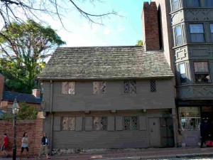
Paul Revere House in North Square

Paul Revere House in North Square

The Paul Revere house was constructed in 1680 where Mather’s home had once stood. Revere purchased it in 1770 and lived here until the 1780’s, when he moved a few blocks away to a house with a harbor view. The Pierce / Hitchborn house, next door to the Revere House, was built around 1711. These houses, along with the Old Corner Book Store and Old State House are the oldest remaining structures in Boston.

The opulent Clark-Frankland and Hutchinson mansions were build just off of North Square after 1710. Hutchinson’s mansion was gutted in 1765 in protest over the Stamp Act. Both the Clark-Frankland and Hutchinson mansions were torn down in 1834 to allow for street widening.

In 1890, Rose Fitzgerald (Kennedy) was born at 4 Garden Court Street, just across the street from where the Hutchinson mansion had stood. Rose later married Joseph P. Kennedy and was the mother of President John F. Kennedy, and Senators Robert and Edward Kennedy. There is a plaque marking the site of her birth on Garden Street just off of North Square. In the mid 1800s, North Square was also home to two Bethels – churches specifically built to minister to the needs of sailors.

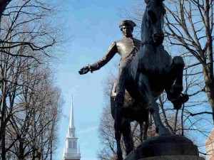
Paul Revere & Old North Church

Paul Revere Statue w/View of Old North Church

In 1721, the construction of the Anglican Christ Church (Old North) began and was completed in 1723. In 1775, the Christ Church belfry was used to hang the “two if by sea” lanterns that warned Patriots of the British march on Lexington and Concord and was the start of Paul Revere’s Ride.

The Charles Bulfinch designed New North Congregational Church on Hanover Street was built between 1802 and 1804.  The Church was originally Congregationalist, but it switched to Unitarian in 1813.  It was sold to the Roman Catholic Diocese of Boston in 1862. It is the last Bulfinch designed church standing in Boston.

After the American Revolution, the North End began transitioning to a largely working class neighborhood with the influx of labor associated with the shipping industry. Wharfs and warehouses were built to support maritime trade and shipbuilding. And, along with the often drunken and violent sailors, came the requisite gamblers, whores and criminals. To proper Bostonians, it became a dangerous slum, a place to be avoided.

From early on there was an Irish population in Boston. Their numbers were small, but grew to about 7,000 by 1830. The Irish population really swelled during the Great Potato Famine when a reported 13,000+ Irish moved to Boston during 1847 alone. The North End was their primary destination.

By 1850, over half the North End’s population of 23,000 was Irish. This peaked at about 15,000 in 1880. With the influx of new ethnic groups, many of the Irish moved to the South End. By 1890, North End’s Irish population had dropped to 5,000 and by the turn of the century it was down to 3,000.

In the 1870’s, the North End became home to an Eastern European Jewish population. In the early 1900s, Jews made up almost one third of the North End’s population, many settling along Salem Street. By the 1920’s, most had moved to Boston’s West and South End, then on to Dorchester, Brookline, Newton, Chelsea and Revere.

The last ethnic group to settle in the North End was the Italians. Immigration started in the 1860s with a small group from Genoa. This was followed by and influx from other Italian regions including Sicily, Milan, and Naples. Each regional group settled in its own distinct North End enclave.

By 1900, the North End Italian population had reached 14,000. By 1920, this number grew to 37,000, with its peak of more than 44,000 in 1930. The North End was now almost completely Italian – and very crowded.

The census puts today’s North End population at about 10,000, of which only 40% are of Italian descent. The remaining residents are a mix of young professionals, college students and others. North End politics are still dominated by Italian Americans.

The North End remains Boston’s Little Italy. It retains a wonderful and distinct “Old Word” feeling and boasts fantastic collection of new and old Italian restaurants, cafes, bakeries and markets.  It is one of the most European-feeling neighborhoods in America.

It is the oldest neighborhood in Boston.  Having existed for over 375 years, is home to some of the most important and historic venues in America as well as some of the most significant Freedom Trail sites.

For more historical information, visit this wonderful five part series by Guild Nichols.